
Alum Shale Properties – Sweden
Related News
All projects are advanced within Sweden’s defined mining legislation and environmental regulatory structure.
Overview
From May 2023 to May 2024, District Metals received approval from the Bergsstaten (Mining Inspectorate) for mineral license applications that cover areas prospective for Alum Shale deposits (Figures 1 and 2) that include Tåsjö nr 101 to 108, Malgomaj nr 1001 to 1003, and Österkälen nr 101 located in the Jämtland and Västerbottens Counties, north-central Sweden (Figure 1).
Alum Shale is the host rock for District’s 100% owned Viken Energy Metals Deposit which contains the largest undeveloped mineral resource estimate of uranium in the world along with significant mineral resource estimates of vanadium, molybdenum, nickel, copper, zinc, and other important and critical raw materials1.
Alum Shale deposits in Sweden typically contain a large inventory of critical energy metals that will be required as part of the green energy transition. In addition, potentially viable Alum Shale deposits are large and shallow, which simplifies and lowers the cost of the exploration, discovery, and development stages.
Figure 1: Location Map
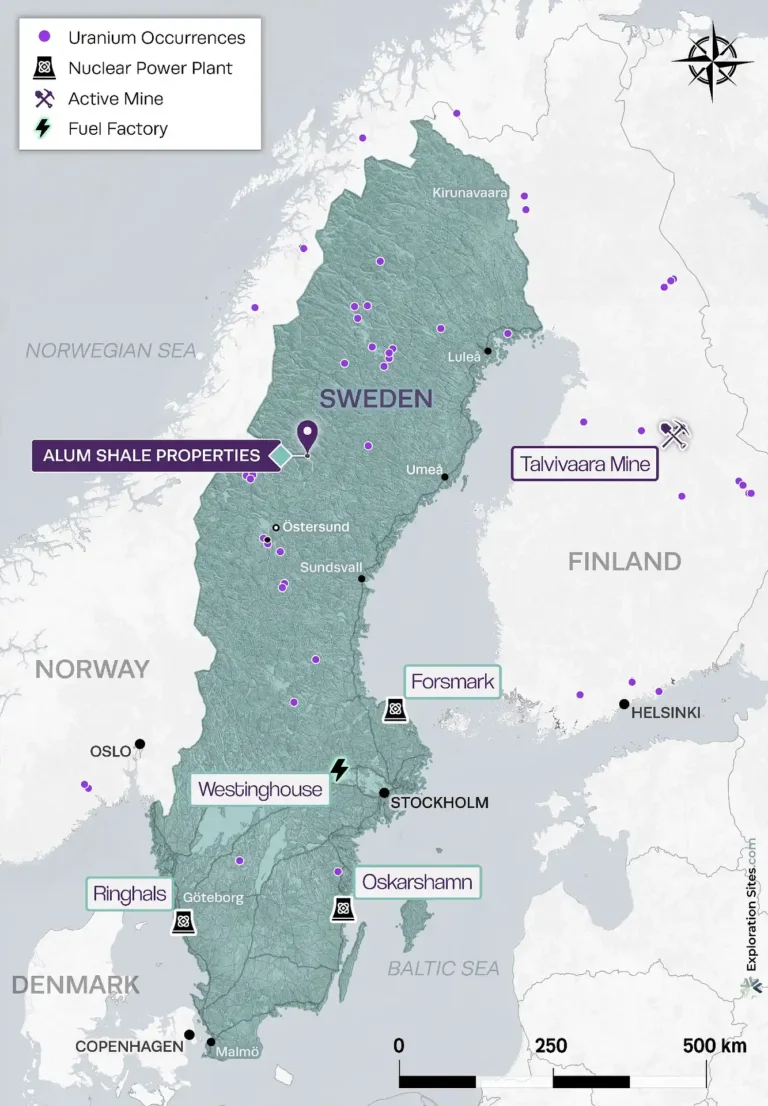
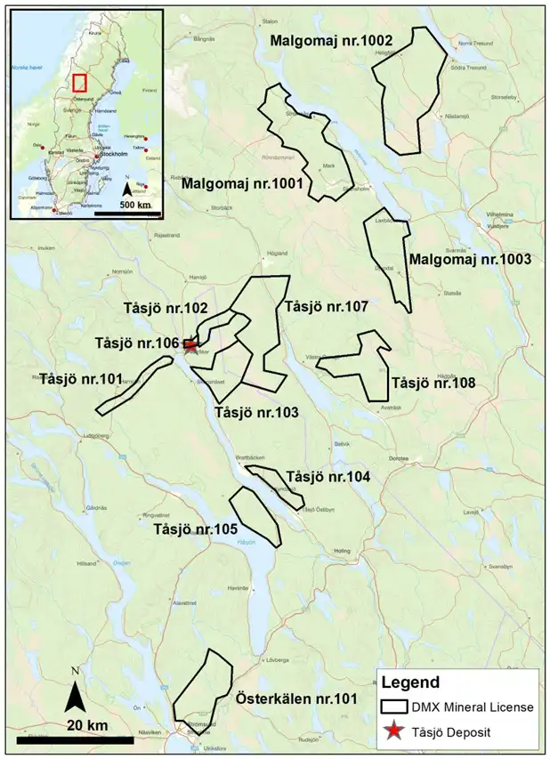
Figure 2: Alum Shale Properties
Tåsjö Property Highlights
- The Tåsjö nr 101 to 108 mineral licenses cover an area of 34,317 hectares (ha) that are prospective for uranium, REE, phosphate, vanadium, molybdenum, nickel, zinc, and copper.
- In the Tåsjö area, Cambro-Ordovician sedimentary units overlie the Proterozoic intrusive basement, which is a similar geological setting that hosts the Viken Deposit.
- The Tåsjö Field was historically estimated to host 75 to 150 million tonnes grading 0.03 to 0.07% U3O8, 0.11 to 0.24% REE, and 3.75 to 7.5% phosphate (P2O5)3,4. The potential quantity and grade of the Tåsjö Field is conceptual in nature and there has been insufficient exploration to define a mineral resource and it is uncertain if further exploration will result in the target being delineated as a mineral resource. The quantity and grade of the historical exploration target. There are no defined methods or parameters used in determining the quantity and grade of the exploration target estimate.
- Shallow historical drilling in the Tåsjö area returned positive results for uranium, REE, and phosphate in the Ordovician lycophoria schist while the much thicker underlying Cambro-Ordovician Alum Shale (Viken Deposit host unit) was not fully explored4.
- The Tåsjö area hosts one of the thickest units of Alum Shale in Sweden that can reach up to 400 meters in thickness due to folding and overthrusting4.
- Mineral License Tåsjö nr 104 contains a historical drill hole completed by the Swedish Geological Survey (SGU) in 1979 that encountered Alum Shale from surface to the end of hole depth at 258.3 m. It was logged several years after drilling and the drill core was not assayed. The drill results can be found in the Geological Survey of Sweden (SGU) database: https://www.sgu.se/en/products/geological-data/.
The Company is not treating the Alum Shale Properties as a mineral project material to the Company. District has not undertaken any independent investigation of the drill results nor has it independently analyzed the drill results in order to verify the results. District considers these drill results relevant as the Company is using this data as a guide to plan exploration programs. The Company’s current and future exploration work includes verification of the historical data through drilling.
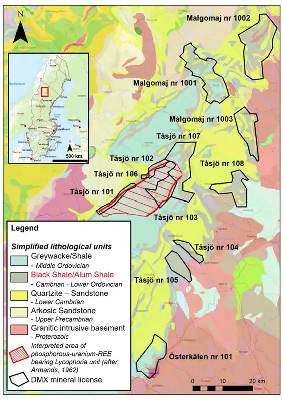
Figure 3: Geological Map with Alum Shale Properties
Tåsjö nr 101 to 108 Mineral Licenses
The Tåsjö Property is situated in the Jämtland and Västerbottens Counties, north-central Sweden, approximately 550 km north-northwest of Stockholm, Sweden. Infrastructure is well developed in the area with daily air service, as well as rail and truck freight services. Electrical power and modern communications are also readily available in the area.
At Tåsjö Field, Alum Shale of Upper Cambrian age is found within the Fjällbränna Formation and is overlaid by the Ordovician Norråker Formation (previous Graywacke-Shale Formation). The Norråker Formation was deposited in a hinge zone representing the transition from a limestone dominated shelf facies towards east and successively deeper marine environment towards west with turbidite facies epiclastic sediments. Due to tectonic deformation and thrusting the thickness of the Alum Shale locally becomes more than 300 m thick. At Tåsjöberg, drill hole Kyrk-Tåsjö 79001 encountered Alum Shale from surface to a depth of 258.3 m, which was logged several years after drilling and was never assayed. The drill results can be found in the Geological Survey of Sweden (SGU) database: https://www.sgu.se/en/products/geological-data/.
The basal part of the overlying Norråker Formation is a calcareous, glauconitic, phosphatic sand- siltstone that is 5 to 8 m thick. It contains several coarse to fine repetitions until it passes into overlying siltstone and shale. This glauconitic-phosphatic unit is found throughout the Lower Paleozoic sequence from Skåne to Jämtland on top of the Alum Shale Formation. In the Tåsjö area this phosphatic unit is unusually thick. The phosphorus sediments are thought to have formed by upwelling of cold seawater onto a warmer shelf causing precipitation of apatite similar to phosphorite deposits.
In 1957, AB Atomenergi (Swedish Atomic Energy Company) discovered anomalous uranium in the Tåsjö Field in northernmost Jämtland close to the border to the Västerbotten County. Uranium was found in glauconite-phosphorite shale within the basal Ordovician unit that is outcropping sporadically within an area of 20 to 30 km long and 10 km wide. In total 68 drill holes were completed from 1961 to 1964 by AB Atomenergi. The area has also been drilled by Stora Kopparberg AB (7 drill holes), SGU (38 drill holes), and Vattenbyggnadsbyrån (41 drillholes), which totals 8,005 m of drilling. The investigations were focused on the Lycophoria Schist with little attention given to the Alum Shales2. Approximately 176 exploration holes for over 7,000 m have been drilled in the Tåsjö area, with the average depth being 42 m.
Both Mawson Energy and Continental Precious Minerals held mineral licenses in the Tåsjö area from 2005 to 2012 for uranium and vanadium. Mawson drilled 53 shallow holes with an average depth of 40 m at the Kronotorpet prospect in the Tåsjö Field, and Continental Precious Minerals drilled 378 m in four holes3,4.
Malgomaj nr 1001 to 1003 Mineral Licenses
Malgomaj nr 1001 is covered by Alum Shale and quartz-rich meta-sediments.
No airborne radiometric or VLF data was available for Malgomaj nr 1001.
Tectonic thickening of the Alum Shale is strongly suggested by the SGU geological map in the northern half of Malgomaj nr 1001 where a repeating sequence of Alum Shale and quartz-rich meta-sediments is shown.
Only two till samples were collected from the area by SGU, one in the center and one in the south, both showing anomalous U values (8.2 ppm in the center and 6 ppm in the south) as well as one value of 21 ppm Mo in the center.
Six grab rock samples from Malgomaj nr 1001 are reported in the SGU database, confirming the presence of Alum Shale with values up to 33 ppm U, 577 ppm V, 111 ppm Ni and 160 ppm Mo.
Malgomaj nr 1003 is characterized by an extensive presence of Alum Shale at surface.
The historical airborne radiometric survey indicates moderate to high uraniferous radiometric values over most of Malgomaj nr 1003, with the highest values also grouped in the center part of the application. No airborne VLF geophysical data was available for this area.
Significant tectonic thickening within Malgomaj nr 1003 is indicated by the SGU geological maps, with both the Alum Shale and the quartz-rich meta-sediments repeating within a nappe system.
The SGU glacial till survey shows multiple samples with anomalous uranium in the 3.5 to 11.4 ppm U range scattered all over Malgomaj nr 1003. In the central part of the area cover by the license application, several samples show anomalous vanadium up to 43.5 ppm V as well as anomalous phosphate up to 0.34 % P2O5 that is associated with REE of the Early Ordovician phosphatic siltstone in the Tåsjö area. This is further confirmed by the presence of anomalous lanthanum up to 32.7 ppm La in the glacial till samples from the same area. Molybdenum in the glacial till samples generally shows moderate anomalous values that reach up to 56 ppm Mo, while nickel shows values up to 46 ppm Ni.
Alum Shale has been confirmed within Malgomaj nr 1003, and eight grab samples showed values of up to 47 ppm U, 504 ppm V and 175 ppm Mo.
Österkälen nr 101 Mineral License
Österkälen nr 101 is covered by Alum Shales at surface as well as both the overlying carbonate-rich meta-sediments and the lower quartz-rich meta-sediments.
The historical airborne radiometric survey shows moderate uraniferous radiometric values with small but strongly radioactive areas in the south and north. Österkälen nr 101 is almost in its entirety characterized by a strong low-resistivity anomaly, based on the VLF airborne survey.
Tectonic thickening is likely given the presence of mapped overthrust faults.
No SGU glacial till surveys cover the area of this mineral license application or surrounding area.
The Scandinavian Alum Shales
The Baltoscandian Platform, from Finnmark in northern Norway to Skåne in southern Sweden, was an area of great stability during the Late Cambrian, with deposition of a thin (10 to 60 m) shale facies along with large amounts of organic matter. This shale deposition started in many areas in the Middle Cambrian and continued in some areas into the earliest Ordovician (Tremadoc). The content of organic matter is commonly in the order of 10%, locally over 20% and very occasionally up to almost 30%. In areas such as Närke, Ostergötland and Kinnekulle, that have not been influenced by temperatures in excess of 100°C, the brown shales yield significant amounts of oil (Fischer assays of 6 to 7%). In other areas, oil-yields are lower or absent; the shales are darker in colour, the organic matter varying in maturation from bituminous to semi-anthracitic or even anthracitic and graphitic towards the interior of the Caledonides.
These organic-rich shales, composing the Alum Shale Formation, are remarkable for their syngenetic concentration of a variety of trace elements, in particular, uranium and vanadium, but also molybdenum, nickel, zinc, copper, rare earth elements, potash and phosphate. Throughout Scandinavia, uranium contents are highest in the Peltura scarabaeoides zone reaching a maximum of 306 ppm over a thickness of 3.6 m in the Ranstad area of the Billingen-Falbygden outlier. Vanadium contents generally (Jämtland excepted) do not exceed 1,000 ppm in the Upper Cambrian but rise rapidly between 2,000 to 3,000 ppm in the Dictyonema zones of the Tremadoc. Even in areas where the general level of these trace elements is lower, the variation in their concentrations is closely related to the stratigraphy. This may also be the case further to the south and southwest where black shales of similar age occur in Poland, in the Anglo-Welsh area, and in eastern Canada on Avalon and in the Maritime Provinces.
The Alum Shale Formation contains Sweden’s most important reserve of fossil energy; oil yields are significant and greatly increased by retorting in hydrogen under pressure. The formation contains the largest uranium resource in Europe, the uranium-rich unit of the Billingen-Falbygden outlier alone containing about a million tonnes of uranium. In the Caledonides, tectonically repeated alum shale successions, several tens of meters thick, contain a combination of unusually high trace element concentrations (200-240 ppm U, 350-400 ppm Mo, 1500-2000 ppm V). The Alum Shale Formation has considerable economic potential5.
Exploration activities are conducted under defined permits issued in accordance with Swedish mining legislation and environmental regulations. Activities are time-bound and subject to oversight by relevant national and regional authorities.
References
1 See District Metals’ news release dated April 29, 2025.
3 Armands, G., 1964: Geologiska undersökningar i Tåsjö-området under 1963 och 1964 (in Swedish); AB Atomenergi KOP-102. [English translation: Exploration in the Tåsjö area, 1963 to 1964]. The Company is not treating this historical exploration target estimate as a current mineral resource and a qualified person has not done sufficient work to classify this estimate as a current mineral resource. The historical exploration target estimate predates current CIM (Canadian Institute of Mining, Metallurgy and Petroleum) categories, and Company is not aware of any more recent mineral resource estimate for the Tåsjö Property.
4 Browne, A., 2008: Report on Current Resource Estimates for Klappibacken and Duobblon Uranium Properties, and Review of Tåsjö Uranium Project, Northern Sweden. Prepared for Mawson Resources Limted by Andrew Browne of GeoSynthesis Pty Ltd. Report number 080204. Report date: 22 February 2008.
5 Andersson, A., Dahlman, B . , Gee , D. G . , and Snäll, S . , 1985: The Scandinavian Alum Shales. Sveriges geologiska undersökning, Ser. Ca, No. 56, pp. 1-50. Uppsala 1985.