District Intersects Strong Feeder Zone Mineralization including 9.8 m at 2.34% CuEq on the Tomtebo Property
September 7, 2021 – District Metals Corp. (TSX-V: DMX) (FRA: DFPP); ("District" or the “Company”) is pleased to report assay results on the last six drill holes (TOM21-017 to -022) from the Spring 2021 drill program at the high grade polymetallic Tomtebo Property located in the Bergslagen Mining District in south-central Sweden.
Drill holes TOM21-017 and -018 were drilled west of and below historic open pits where copper sulphides were historically extracted at the Gårdsgruvans zone in the southwest portion of the Tomtebo Mine. Hole TOM21-017 successfully intersected vein networks of copper-rich sulphides within strongly altered felsic volcanic rocks down dip of previously reported hole TOM21-016, which returned 17.2 m at 1.42% CuEq1 (191.6 to 208.8 m).
The Rödbergsgruvan zone was drilled with holes TOM21-019 to -022 where the strongest mineralization was encountered in hole TOM21-019 as disseminated, vein/stringer, and semi-massive copper sulphides.
The following drill intercepts are highlighted below:
- TOM21-017 intersected multiple stacked mineralized lenses comprising:
- 13.4 m at 0.68% CuEq (88.1 to 101.5 m)
- 16.2 m at 0.87% CuEq (206.8 to 223.0 m)
- 5.6 m at 7.11% ZnEq2 (269.2 to 274.8 m)
- 5.05 m at 2.86% CuEq (278.1 to 283.15 m)
- 2.0 m at 2.18% CuEq (295.3 to 297.3 m)
- TOM21-019 intersected 9.8 m at 2.34% CuEq (69.5 to 79.3 m) including 4.2 m at 3.7% CuEq (70.5 to 74.7 m).
Drill hole locations and a cross section are shown in Figures 1 and 2, drill core photos are shown in Figures 3 and 4, and drill assay results are shown in Table 1.
Garrett Ainsworth, CEO of District, commented: “Drill assay results from the Gårdsgruvans and Rödbergsgruvan zones continue to expand a large and robust copper-gold feeder zone that is wide open at depth and to the southwest towards favourable geophysical anomalies. Hole TOM21-017 encountered numerous stacked lenses of polymetallic sulphide mineralization that indicates multiple mineralizing events occurred over a long period of time, which is another important feature of other large polymetallic deposits in the Bergslagen District.
We are excited to commence our fully funded 5,000 m Phase II drill program at Tomtebo in October with enhanced targeting through the compilation of our recently acquired exploration data. Step out drilling at the historic Tomtebo Mine will be guided by our drill assays, whole rock geochemical and geological interpretations. Regional drilling will focus on coincident gravity, magnetic, and conductive anomalies that are located up to 1 km northeast and 600 m southwest along trend from the Tomtebo Mine.”
Drill Hole Summaries from Gårdsgruvan Zone
TOM21-017
Hole TOM21-017 was drilled at an angled orientation (-58° dip) to the southeast (110° azimuth) as a step out below previously reported hole TOM21-016, which returned 17.2 m at 0.94% Cu and 0.28 g/t Au (191.6 to 208.8 m). Hole TOM21-017 is dominated by altered felsic volcanic rocks with varying assemblages of phlogopite-muscovite and cordierite/andalusite blasts. Locally, well preserved volcanic textures indicate arcuate-elliptical perlitic features, supporting a glassy lava or very shallow intrusive (rhyolitic lava dome) setting as a host to a significant part of the vein-style sulphide mineralization. These glassy rhyolitic domes often mark the center of VMS systems, whereas the massive sulphide mineralization would normally occur at the margin of these rhyolitic bodies. Multiple intervals of dark grey quartz-chlorite-anthophyllite-cordierite alteration with local pyrite-chalcopyrite impregnations and stringers were observed from 92.0 to 99.0 m, 107.0 to 110.0 m, and 155.0 to 166.0 m.
A zone of strongly altered dark-grey quartz-phlogopite-chlorite-cordierite alteration with locally abundant anthophyllite and magnetite is associated with significant pyrrhotite-pyrite-chalcopyrite mineralization from 193.0 to 223.0 m, which is interpreted as ‘feeder’ sulphide veins in the core of a sub-seafloor hydrothermal system.
An additional zone of intense dark phlogopite-chlorite-cordierite altered rocks starts at 267.0 m with both copper and silver-zinc-lead vein-style mineralization. Veinlet and disseminated silver-zinc-lead mineralization was observed from 269.0 to 275.0 m, which could indicate several pulses of mineralization that cross-cut and precipitated at different temperatures. The alteration intensity decreases at a depth of 297.0 m until the end of the hole depth at 320.0 m.
TOM21-018
Hole TOM21-018 was drilled at an angled orientation (-60° dip) to the southeast (105° azimuth) as a follow up to historic hole TOM67-001, which was drilled horizontally to the west from the exploration drift on the -200 m level, and returned 4.3 m at 1.35% Cu. Hole TOM21-018 was dominated by relatively unaltered fine grained felsic volcanic ash silt-sandstones (hanging wall type) with intercalated meter sized mafic dykes to a depth of 99.0 m. The alteration intensity increases, dominated by quartz-phlogopite-muscovite with local disseminations of pyrite and cordierite/andalusite blasts. Two zones of strongly altered felsic volcanic rocks host disseminated, stringer, and vein-style copper sulphide mineralization that is dominated by pyrite-pyrrhotite-chalcopyrite. These mineralized intervals were observed from 175.0 to 195.0 m and 218.0 to 237.0 m. Moderately quartz-phlogopite/muscovite altered felsic volcanic rocks with local trace pyrite continued until the end of hole depth at 291.0 m.
Drill Hole Summaries from Rödbergsgruvan Zone
Holes TOM21-019 to -022 were drilled from the same pad in the southern part of the historic Tomtebo Mine. The planned holes were designed to test the 3D modelled mineralized domains anchored by historic drill holes TOM56-003 and -004 along with the historic Rödbergsgruvan mine pit.
TOM21-019
Hole TOM21-019 (006° azimuth, -45° dip) followed up on historic hole TOM56-003 which returned 2.3 m at 21% Zn, 5% Pb, and 0.6% Cu (50.0 to 52.3 m) that was within 8.3 m at 0.5% Cu (49.0 to 57.3 m). Hole TOM21-019 was initially dominated by moderate to strongly altered felsic volcanic rocks that contained two zones of pyrite-chalcopyrite impregnation associated with dark, quartz-phlogopite/chlorite-anthophyllite-cordierite alteration from 30.0 to 37.0 m and 53.0 to 57.0 m. A significant mineralized zone, dominated by semi-massive pyrite-pyrrhotite-chalcopyrite and strong impregnation plus vein/stringer-style mineralization was observed from 68.0 and 86.0 m. Weak zinc-lead sulphide (sphalerite-galena) mineralization was observed from 68.0 and 72.0 m. Moderately altered quartz-phlogopite/muscovite-andalusite/cordierite with local relicts of perlitic features continue until the end of the hole depth at 150.0 m.
TOM21-020
Hole TOM21-020 (000° azimuth, -65° dip) was designed to step out below TOM21-019. Hole TOM21-020 was dominated by moderate to strongly altered felsic volcanic rocks, similar to TOM21-019 and other drill holes within the Gårdsgruvan zone. Meter sized intervals of pyrite-pyrrhotite dominant semi-massive, vein, and stringer sulphides were observed at 105.0 m and 127.0 m. Altered felsic volcanic rocks continue with cross cutting meter sized mafic dykes until the end of hole depth at 190.0 m.
TOM21-021 & -022
Holes TOM21-021 (330° azimuth, -45° dip) and TOM21-022 (045° azimuth, -50° dip) stepped out to the west and east of holes TOM21-019 and -020 to determine if sulphide mineralization extends along an east-west strike direction. Both drill holes have similar lithological and alteration signatures as TOM21-019 and -020. Intervals of sulphide impregnation (pyrite-pyrrhotite dominated) were observed from 40.0 to 48.0 m in TOM21-021, and from 56.0 to 67.0 m in TOM21-022. Both holes were terminated at an end of hole depth of 150.0 m.
Figure 1: Plan View of Drill Holes at Tomtebo Mine
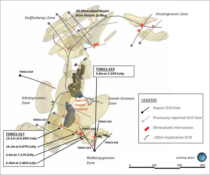
Figure 2: Cross Section Looking North-Northeast at Holes TOM21-016 and -017
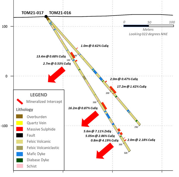
Table 1: Tomtebo Drill Assay Results
| Drill Hole | Depths and Interval | Assay Results | ||||||||||
| Hole ID | Azimuth | Dip | Total Depth (m) | From (m) | To (m) | Interval (m) | Cu (%) | Au (g/t) | Ag (g/t) | Zn (%) | Pb (%) | CuEq (%) |
| TOM21-017 | 110 | -58 | 320 | 88.10 | 101.50 | 13.40 | 0.55 | 0.09 | 2.0 | 0.01 | 0.00 | 0.68 |
| incl. | 88.10 | 97.40 | 9.30 | 0.67 | 0.12 | 2.5 | 0.01 | 0.00 | 0.83 | |||
| incl. | 88.10 | 89.70 | 1.60 | 2.15 | 0.35 | 8.8 | 0.05 | 0.00 | 2.65 | |||
| incl. | 96.50 | 97.40 | 0.90 | 0.66 | 0.29 | 2.0 | 0.00 | 0.00 | 1.01 | |||
| incl. | 100.40 | 101.50 | 1.10 | 0.59 | 0.04 | 1.5 | 0.01 | 0.00 | 0.65 | |||
| 106.70 | 109.40 | 2.70 | 0.39 | 0.10 | 2.0 | 0.01 | 0.00 | 0.53 | ||||
| 206.80 | 223.00 | 16.20 | 0.57 | 0.20 | 6.0 | 0.03 | 0.01 | 0.87 | ||||
| incl. | 206.80 | 215.00 | 8.20 | 0.79 | 0.28 | 6.7 | 0.04 | 0.01 | 1.19 | |||
| incl. | 211.00 | 215.00 | 4.00 | 0.97 | 0.42 | 8.6 | 0.03 | 0.00 | 1.53 | |||
| 269.20 | 274.80 | 5.60 | 0.14 | 0.04 | 16.0 | 5.63 | 0.68 | 2.81 | ||||
| incl. | 269.20 | 271.70 | 2.50 | 0.14 | 0.07 | 34.7 | 9.98 | 1.48 | 5.04 | |||
| 278.10 | 283.15 | 5.05 | 1.30 | 0.58 | 38.9 | 0.63 | 0.75 | 2.86 | ||||
| incl. | 281.20 | 283.15 | 1.95 | 2.13 | 0.69 | 89.0 | 1.30 | 1.78 | 4.95 | |||
| 291.00 | 291.80 | 0.80 | 3.07 | 0.54 | 37.9 | 0.29 | 0.02 | 4.19 | ||||
| 295.30 | 297.30 | 2.00 | 1.47 | 0.40 | 19.6 | 0.14 | 0.03 | 2.18 | ||||
| TOM21-018 | 105 | -60 | 290.8 | 133.70 | 134.60 | 0.90 | 0.54 | 0.35 | 8.1 | 0.03 | 0.01 | 1.03 |
| 218.20 | 219.30 | 1.10 | 0.64 | 0.30 | 11.7 | 0.03 | 0.01 | 1.12 | ||||
| 232.50 | 236.20 | 3.70 | 0.54 | 0.15 | 5.9 | 0.02 | 0.00 | 0.78 | ||||
| 280.80 | 282.00 | 1.20 | 0.60 | 0.32 | 20.5 | 0.01 | 0.01 | 1.17 | ||||
| TOM21-019 | 6 | -45 | 150 | 30.80 | 31.80 | 1.00 | 0.60 | 0.08 | 3.5 | 0.04 | 0.01 | 0.74 |
| 34.40 | 36.40 | 2.00 | 0.46 | 0.15 | 4.4 | 0.05 | 0.01 | 0.69 | ||||
| 69.50 | 79.30 | 9.80 | 1.06 | 0.61 | 23.8 | 0.59 | 0.37 | 2.34 | ||||
| Incl. | 70.50 | 74.70 | 4.20 | 1.67 | 0.97 | 38.6 | 0.83 | 0.62 | 3.70 | |||
| TOM21-020 | 0 | -65 | 190 | 42.20 | 47.20 | 5.00 | 0.38 | 0.18 | 2.9 | 0.03 | 0.01 | 0.63 |
| Incl. | 45.20 | 47.20 | 2.00 | 0.42 | 0.14 | 2.9 | 0.03 | 0.00 | 0.62 | |||
| 70.40 | 71.30 | 0.90 | 0.34 | 0.40 | 5.4 | 0.04 | 0.00 | 0.85 | ||||
| 126.20 | 127.20 | 1.00 | 0.19 | 0.15 | 9.7 | 0.15 | 0.26 | 0.61 | ||||
| TOM21-021 | 330 | -45 | 150 | 45.30 | 46.10 | 0.80 | 0.47 | 0.18 | 3.6 | 0.07 | 0.00 | 0.73 |
| TOM21-022 | 45 | -50 | 150 | No Significant Results | ||||||||
Notes:
- All intervals are core lengths, and true thicknesses are yet to be determined. A mineral resource modeling is required before true thicknesses can be estimated.
- Cut-off grade of 0.50% CuEq utilized, which may include up to 2.0 m of internal dilution. Underground mining cut-off at the nearby Garpenberg Mine was US$32/tonne in 2020.
- Metal prices used in USD for the CuEq cut-off calculation were based on Ag $15.00/oz, Au $1650/oz, Cu $2.15/lb, Zn $0.85/lb, and Pb $0.75/lb.
- CuEq equals = Cu% + (Au g/t x 1.1192) + (Ag g/t × 0.0102) + (Zn % x 0.3953) + (Pb % x 0.3488)
- The use of CuEq is to calculate cut-off grades for exploration purposes, and no adjustments were made for metal recovery.
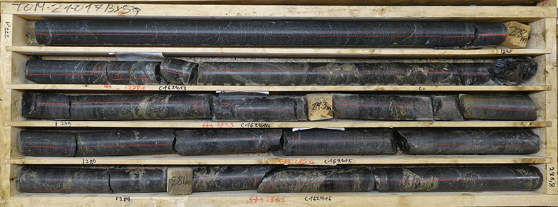
Figure 3: TOM21-017 Sulphide Mineralization from 277.1 to 281.8 m
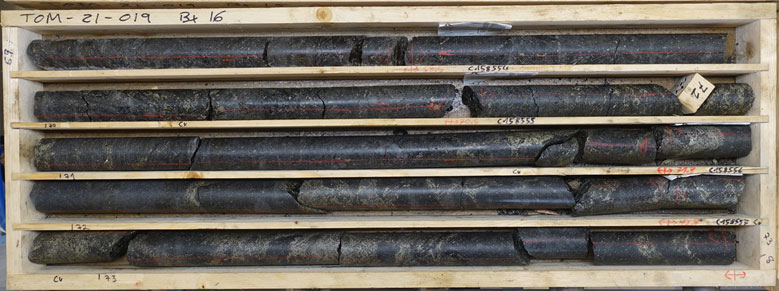
Figure 4: TOM21-019 Sulphide Mineralization from 69.0 to 73.8 m
References
1 Metal prices used in USD for the CuEq cut-off calculation were based on Ag $15.00/oz, Au $1650/oz, Cu $2.15/lb, Zn $0.85/lb, and Pb $0.75/lb. CuEq equals = Cu% + (Au g/t x 1.1192) + (Ag g/t × 0.0102) + (Zn % x 0.3953) + (Pb % x 0.3488). The use of CuEq is to calculate cut-off grades for exploration purposes, and no adjustments were made for metal recovery.
2 Metal prices used in USD for the ZnEq cut-off calculation were based on Ag $15.00/oz, Au $1650/oz, Cu $2.15/lb, Zn $0.85/lb, and Pb $0.75/lb. ZnEq equals = Zn% + (Ag g/t × 0.0257) + (Au g/t x 2.831) + (Cu% × 2.529) + (Pb% × 0.882). The use of ZnEq is to calculate cut-off grades for exploration purposes, and no adjustments were made for metal recovery.
Technical Information
All scientific and technical information in this news release has been prepared by, or approved by Garrett Ainsworth, PGeo, President and CEO of the Company. Mr. Ainsworth is a qualified person for the purposes of National Instrument 43-101 - Standards of Disclosure for Mineral Projects.
The drill core reported in this news release was logged and prepared at the District Metals AB core facility in Säter, Sweden before submittal to ALS Geochemistry in Malå, Sweden where the drill core is cut, bagged, and prepared for analysis. Sample pulps were sent to ALS Geochemistry in Ireland (an accredited mineral analysis laboratory) for analysis. Samples were analyzed using a multi-element ultra trace method combining a four-acid digestion with ICP-MS analytical package (“ME-MS61”). Over limit sample values were re-assayed for: (1) values of copper >1%; (2) values of zinc >1%; (3) values of lead >1%; and (4) values of silver >100 g/t using the high-grade material ICP-AES analytical package (“ME-OG62”). Additional over limit sample values were re-assayed for: (1) values of zinc >30%; (2) values of lead >20% using the high precision analysis of base metal ores AAS analytical package (“Zn, Pb-AAORE”). Gold, platinum, and palladium were analyzed using the 30 g lead fire assay with ICP-AES finish analytical package (“PGM-ICP23”). Certified standards, blanks, and duplicates were inserted into the sample shipment to ensure integrity of the assay process. Selected samples were chosen for duplicate assay from the coarse reject and pulps of the original sample. No QA/QC issues were noted with the results reported.
Some of the data disclosed in this news release is related to historical drilling results. District has not undertaken any independent investigation of the sampling nor has it independently analyzed the results of the historical exploration work in order to verify the results. District considers these historical drill results relevant as the Company is using this data as a guide to plan exploration programs. The Company's current and future exploration work includes verification of the historical data through drilling.
Mr. Ainsworth has not verified any of the information regarding any of the properties or projects referred to herein other than the Tomtebo Property. Mineralization on any other properties referred to herein is not necessarily indicative of mineralization on the Tomtebo Property.
About District Metals Corp.
District Metals Corp. is led by industry professionals with a track record of success in the mining industry. The Company’s mandate is to seek out, explore, and develop prospective mineral properties through a disciplined science-based approach to create shareholder value and benefit other stakeholders.
The advanced exploration stage Tomtebo Property is located in the Bergslagen Mining District of south-central Sweden is the Company’s main focus. Tomtebo comprises 5,144 ha and is situated between the historic Falun Mine and Boliden’s Garpenberg Mine that are located 25 km to the northwest and southeast, respectively. Two historic polymetallic mines and numerous polymetallic showings are located on the Tomtebo Property along an approximate 17 km trend that exhibits similar geology, structure, alteration and VMS/SedEx style mineralization as other significant mines within the district. Mineralization that is open at depth and along strike at the historic mines on the Tomtebo Property has not been followed up on, and modern systematic exploration has never been conducted on the Property.
For further information on the Tomtebo Property, please see the technical report entitled “NI 43-101 Update Technical Report on the Tomtebo Project, Bergslagen Region of Sweden” dated effective October 15, 2020 and amended and restated on February 26, 2021, which is available on SEDAR at www.sedar.com.
On Behalf of the Board of Directors
“Garrett Ainsworth”
President and Chief Executive Officer
(604) 288-4430
Neither TSX Venture Exchange nor its Regulation Services Provider (as that term is defined in policies of the TSX Venture Exchange) accepts responsibility for the adequacy or accuracy of this release.
Cautionary Statement Regarding “Forward-Looking” Information.
This news release contains certain statements that may be considered “forward-looking information” with respect to the Company within the meaning of applicable securities laws. In some cases, but not necessarily in all cases, forward-looking information can be identified by the use of forward-looking terminology such as “plans”, “targets”, “expects” or “does not expect”, “is expected”, “an opportunity exists”, “is positioned”, “estimates”, “intends”, “assumes”, “anticipates” or “does not anticipate” or “believes”, or variations of such words and phrases or statements that certain actions, events or results “may”, “could”, “would”, “might”, “will” or “will be taken”, “occur” or “be achieved” and any similar expressions. In addition, any statements that refer to expectations, predictions, indications, projections or other characterizations of future events or circumstances contain forward-looking information. Statements containing forward-looking information are not historical facts but instead represent management’s expectations, estimates and projections regarding future events. Forward-looking statements in this news release relating to the Company include, among other things, statements relating to the Company’s planned exploration activities, including its drill target strategy and next steps for the Tomtebo Property; the company’s interpretations and expectations about the mineralization of the Tomtebo Mine; the Company’s belief that the numerous gravity high anomalies identified at the historic Tomtebo Mine provide immense expansion potential; the Company’s belief that the modeled gravity high anomalies at the historic Tomtebo Mine could correspond with polymetallic and/or iron sulphide mineralization, or a mafic unit; and the Company’s belief that the gravity high anomaly located one kilometer to the northeast of the Tomtebo Mine represents a potential grassroots discovery opportunity with a modeled tonnage that compares with the historic production tonnage from the historic Falun Mine.
These statements and other forward-looking information are based on opinions, assumptions and estimates made by the Company in light of its experience and perception of historical trends, current conditions and expected future developments, as well as other factors that the Company believes are appropriate and reasonable in the circumstances, as of the date of this news release, including, without limitation, assumptions about the reliability of historical data and the accuracy of publicly reported information regarding past and historic mines in the Bergslagen district; the Company’s ability to raise sufficient capital to fund planned exploration activities, maintain corporate capacity and satisfy the exploration expenditure requirements required by the definitive purchase agreement between the Company and the vendor of the Tomtebo Property (the "Tomtebo Purchase Agreement") by the times specified therein; and stability in financial and capital markets.
Forward-looking information is necessarily based on a number of opinions, assumptions and estimates that, while considered reasonable by the Company as of the date such statements are made, are subject to known and unknown risks, uncertainties, assumptions and other factors that may cause the actual results, level of activity, performance or achievements to be materially different from those expressed or implied by such forward-looking information, including but not limited to risks associated with the following: the reliability of historic data regarding the Tomtebo Property; the Company’s ability to raise sufficient capital to finance planned exploration (including incurring prescribed exploration expenditures required by the Tomtebo Purchase Agreement, failing which the Tomtebo Property will be forfeited without any repayment of the purchase price); the Company’s limited operating history; the Company’s negative operating cash flow and dependence on third-party financing; the uncertainty of additional funding; the uncertainties associated with early stage exploration activities including general economic, market and business conditions, the regulatory process, failure to obtain necessary permits and approvals, technical issues, potential delays, unexpected events and management’s capacity to execute and implement its future plans; the Company’s ability to identify any mineral resources and mineral reserves; the substantial expenditures required to establish mineral reserves through drilling and the estimation of mineral reserves or mineral resources; the Company’s dependence on one material project, the Tomtebo Property; the uncertainty of estimates used to calculated mineralization figures; changes in governmental regulations; compliance with applicable laws and regulations; competition for future resource acquisitions and skilled industry personnel; reliance on key personnel; title matters; conflicts of interest; environmental laws and regulations and associated risks, including climate change legislation; land reclamation requirements; changes in government policies; volatility of the Company’s share price; the unlikelihood that shareholders will receive dividends from the Company; potential future acquisitions and joint ventures; infrastructure risks; fluctuations in demand for, and prices of gold, silver and copper; fluctuations in foreign currency exchange rates; legal proceedings and the enforceability of judgments; going concern risk; risks related to the Company’s information technology systems and cyber-security risks; and risk related to the outbreak of epidemics or pandemics or other health crises, including the recent outbreak of COVID-19. For additional information regarding these risks, please see the Company’s Annual Information Form, under the heading “Risk Factors”, which is available at www.sedar.com. These factors and assumptions are not intended to represent a complete list of the factors and assumptions that could affect the Company. These factors and assumptions, however, should be considered carefully. Although the Company has attempted to identify factors that would cause actual actions, events or results to differ materially from those disclosed in the forward-looking statements or information, there may be other factors that cause actions, events or results not to be as anticipated, estimated or intended. Also, many of such factors are beyond the control of the Company. Accordingly, readers should not place undue reliance on forward-looking statements or information. The forward-looking information is made as of the date of this news release, and the Company assumes no obligation to publicly update or revise such forward-looking information, except as required by applicable securities laws. All scientific and technical information contained in this news release has been prepared by or reviewed and approved by Garrett Ainsworth, PGeo, President and CEO of the Company. Mr. Ainsworth is a qualified person for the purposes of National Instrument 43-101 - Standards of Disclosure for Mineral Projects.